|
Gapmajang-gil is a hiking trail in Gasi-ri, Pyoseon-myeon, Seogwipo-si, Jeju-do. Gasiri is located in the middle mountainous region and is large enough to occupy half of the Pyoseon-myeon area. For this reason, Gasiri has been designated as a horse pasture since the Goryeo period.
In the Joseon period, the largest horse ranch among the 13 horse ranches in Jeju was also located here. Gammajang, a horse ranch that raised the highest grade of state horses, was also located here. Gammajang-gil is a 20km hiking trail that connects Saseumi Oreum, Ttarabi Oreum, the boundary line of the ranch called jatseong, and cedar and cypress forests. Local residents joined forces to pave the way in 2011.
There is a mini version of Gapmajang-gil called Jjolbeun Gammajang-gil that spans 10km, which is about half of Gammajang-gil. “Jjobeun” is a Jeju dialect for “short.” It opened in November 2012, one year after the opening of Gapmajang-gil.
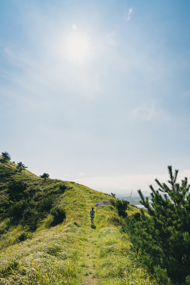
Jjolbeun Gapmajang-gil starts from the Jeongseok Airport Parking Lot and leads to Rape Flower Plaza, Kkotmeoche, Haenggimeoche, Ttarabi Oreum, jatseong, and Keunsaseumi Oreum, then returns to the origin. This path, where horses used to roam, was also used as a racing course for the Jeju International Trail Running Competition.
When you start walking at Rape Flower Plaza, you will pass through a small forest. Here, you can check out Kkotmeoche. Meoche is an underground lava dome that rises to the surface after flowing for a long time. The technical term for this phenomenon is cryptodome. Although it looks similar to a pile of stones, it’s not just a simple rock because it coexists with trees and other plants.
Kkotmeoche (“flower” cryptodome) was created by Hallasan rosebay and Itajii chinkapin growing through the pile of stones. It is called “kkotmeoche” because flowers bloom on the tree above the cryptodome. It is simply amazing to see them take root between rocks. At the bottom, it is filled with green moss and ferns.
If you go a little further from Kkotmeoche, you will find Haenggimeoche across the road. “Haenggi” refers to a brass vessel that holds water. Haenggimeoche was named so because it looked like haenggimul (water in a brass bowl) was on top of the cryptodome. This meoche is 7m in height and 18m in diameter, making it the largest cryptodome in Asia.
After passing Haenggimeoche, ravines and forests continue along Gasicheon Stream. While walking, you will pass several convoluted wooden door-like objects. Although people can come and go easily through it, horses cannot go back because they cannot turn their long bodies inside.
Once Gasicheon Stream is behind you, the road becomes wider, and Ttarabi Oreum (342m) will appear in front. It is flat with almost no incline up to the entrance of the oreum. Ribbons and milestones are placed throughout to guide hikers, and every path leads back to the starting point, so it’s easy to come back when it gets too tough.
The word “ttarabi” is derived from “ttaaebi,” which means “grandfather of the land.” As the name suggests, there are several volcanic oreum around Ttarabi Oreum. Saekki Oreum, about 400m away from Ttarabi, is like its son, Mojioreum, about 1km away, is the son’s wife, and Jangjaoreum, 330m away from Mojioreum, is considered the grandson.
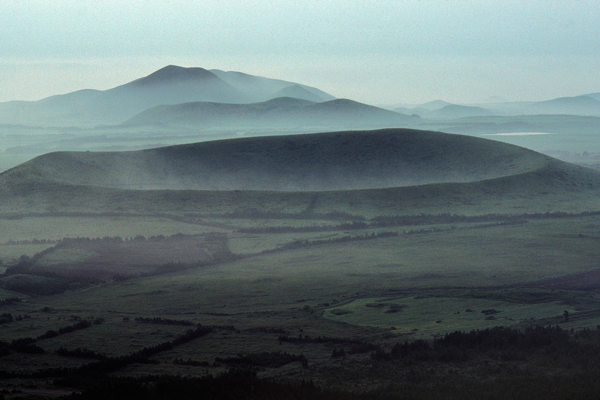
Continue hiking up the stairs and the dirt road for about 20 minutes to reach the top of Ttarabi Oreum. It has three gumburi, or craters. The shape is quite unusual; three small craters are inside a large crater. It also has six peaks, which are very different in appearance from other commonly known oreum.
There are two large peaks that can be called “summits.” If you stand on the western summit, you can see Keunsaseumi Oreum, the wind power plant, and even Hallasan Mountain in the distance. From the observatory on the east side, you can see Gammajang below your feet and Seongsan Ilchulbong Peak in the distance. While most Oreum has only one path, Ttarabi Oreum has trails in all directions, so you can choose whichever direction you want.
When you come back down, you will encounter the cedar forest again, and a path along jatseong will be along the side. Jatseong is the boundary between ranches, a stone wall that confines horses. The jatseong here is one of the best-preserved in Jeju.
After the jatseong path ends and you pass through the traditional archery field, you can go up to Keunsaseumi Oreum, which means “big deer oreum.” It was a habitat for deer in the past, and the shape of the oreum also resembled a deer, hence its name. Since the lava that poured out from volcanic activities stopped and hardened at the mid-slope, you can observe the original topography of the volcanic planation surface. The path to the top is a bit steep compared to other oreum.
|